|
One may not always think of Michigan when thinking about “island hopping” but they have a number of small islands on Lake Michigan with General Aviation (GA) airports. They are perfect for camping, hiking, biking, kayaking (yes, inflatable ones that fit in the aircraft), fishing, and/or all those other kind of outdoor activities a lot of us pilots are interested in. 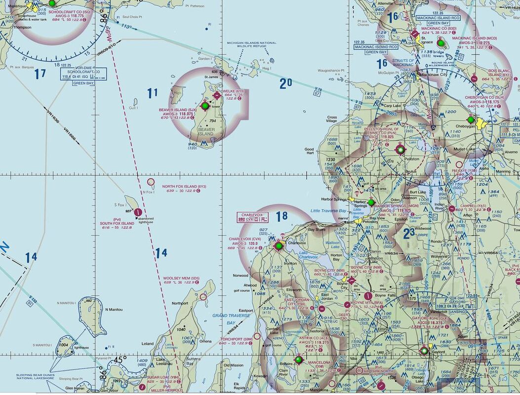 Source: SkyVector All the airports mentioned have an elevation of approximately 650-750 feet and are non-towered. South Fox Island While South Fox Island Airport (3MI2) (https://www.airnav.com/airport/3MI2) looks very nice and tempting, it is privately-owned and, therefore, requires prior permission for access. Mr. David Johnson owns about two-thirds of the island (including the Airport) and the other third is owned by the state of Michigan. So, unless you know the Johnson Family, one may not have any ability or reason to go. 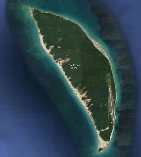 Source: Google Earth North Fox Island This uninhabited island, of 1 mile long by 2 miles wide dimensions, is the perfect place to relax, read a book, and/or practice some outdoor activities. North Fox Island Airport (6Y3) (https://www.airnav.com/airport/6Y3 and https://airfield.guide/images/apt/93/documents/19.PDF) is open to the public during the summer months (normally between April/May and October). Runway 7/25 is a 3,000 x 100 ft turf runway with displaced thresholds on both ends due to trees. It is the perfect spot for camping, hiking, fishing, swimming, etc in a completely remote spot. You may quickly notice that it does not have any services or facilities of any kind. So, it’s just you and nature. Oh, how nice! 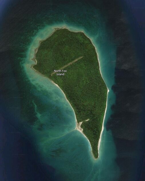 Source: Google Earth The Recreational Aviation Foundation (RAF) has additional information about this airfield on their Airfield Guide, which can be found at https://airfield.guide/filter_airports.asp Beaver Island The island is home to some of the state’s most beautiful beaches, brilliant stars, and crystal clear waters. The only real town on the island is on the northeast corner. There, you can find a few lodges, restaurants, shops, museums, beaches, a lighthouse, the St. James Township Campground, and the George & Althea Petritz Nature Preserve. This island has two airports to choose from: Beaver Island Airport (KSJX) (https://www.airnav.com/airport/KSJX) and Welke Airport (6Y8) (https://www.airnav.com/airport/6Y8). They both appear to sell 100LL. KSJX is the larger of the two but it is more remote (further away from civilization in the rest of the island). 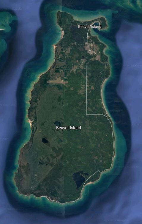 Source: Google Earth KSJX has three runways: Runway 9/27 is a paved, 4,299 x 75 ft runway, Runway 14/32 is a turf, 3,278 x 120 ft runway, and Runway 5/23 is a turf, 2,054 x 120 ft runway. 6Y8 is a privately-owned but publicly used airport; however, prior approval is necessary if you plan on flying in at night. It has two runways: Runway 9/27 is a paved, 2,512 x 30 ft runway and Runway 17/35 is a turf, 3,500 x 140 ft runway. Welke has a golf course and a beach nearby. They can both be reached by foot or bike via East Side Dr and the Little Sand Bay Nature Preserve Trail respectively. Mackinac Island The island is mostly developed on the south end with other private homes and communities scattered around the island. This is where Fort Mackinac, the Jewel Golf Course, Mission Point, the majority of restaurants and hotels, the harbor and port, etc are. The Mackinac Island Airport (KMCD) (https://www.mackinacparks.com/more-info/mackinac-island-airport-2/) is part of the Mackinac Island State Park (https://www.mackinacparks.com/parks-and-attractions/mackinac-island-state-park/), Michigan’s first state park. However, it is important to keep in mind that, while the state park has lots of trails to hike, a visitor center to visit, the British Landing Nature Center to experience, etc, camping and hunting are not allowed. The Airport is the only link with the mainland from early January to mid-April when the ferries start operating again. It has a single paved runway, 8/26, which is 3,501 ft long and 75 ft wide. Landing fees may apply. Note this Airport does not appear to have fuel and is only attended 8 am to 5 pm (with possible reduced hours in the winter). Pilots are encouraged to use pitot covers while parked and to check tubes prior to departure due to mud daubers. Yes, I had to check what those creatures are… They are essentially wasps. So, I imagine the concern does not come from the insects themselves but rather from the nests they can build. In that case, I would check any open compartments: pitot tubes, static sources, engine cowlings, etc.  Source: Google Earth The Airport is adjacent to the Wawashkamo Golf Club and the Mackinac Community Equestrian Center. The island appears to have multiple underground caves, such as the Cave of the Woods by the Airport, the Skull cave, or the Eagle Point cave. However, if you are looking for good views, head to Fort Holmes and/or Arch Rock (although, keep in mind, it might involve quite a few steps). Bois Blanc Island In between Mackinac Island and Bois Blanc Island, there’s Round Island; however, this is a virgin island with nothing but a lighthouse on it. Bois Blanc (https://www.michigan.org/city/bois-blanc-island) appears to be more of a “resident island” than a “tourist island.” However, one can still find a few lodges and B&Bs and plenty of things to do, such as fishing, hiking, swimming, bird watching, or kayaking. The Bois Blanc Island Airport (6Y1) (https://www.airnav.com/airport/6Y1) has a single paved runway. Runway 10/28 is 3,498 x 75 ft. Note this Airport does not appear to have fuel and is mostly unattended. For this reason, flying to it in the winter may not be possible. 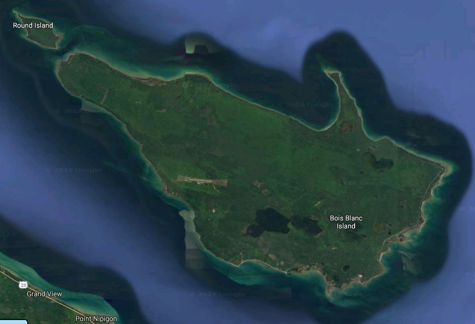 Source: Google Earth Other North Manitou Island is part of the Sleeping Bear National Lakeshore. It used to have a gravel strip (about 4,100 feet according to measurements performed with Google Earth Pro) but I was told by Brad Frederick that it has since closed. However, if you're curious about it, you can take a ferry service there during certain times of the year: https://www.nps.gov/slbe/planyourvisit/plantriptoislands.htm 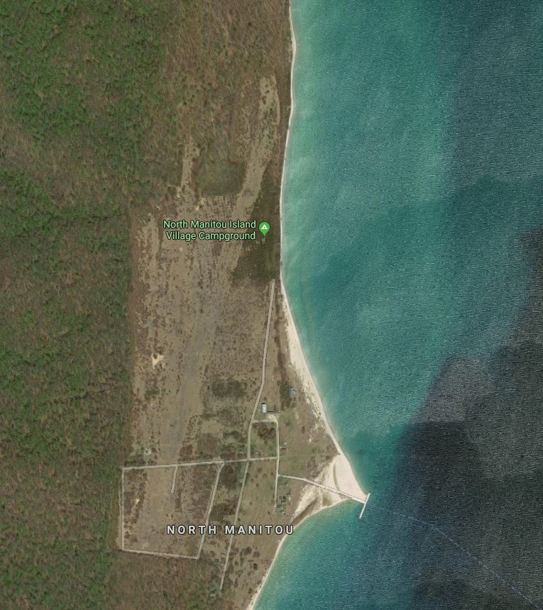 Source: Google Earth Thanks to Jim Ryan, Trout Island has also been added to the list. It is just north of High Island or northwest of Beaver Island; however, keep in mind the grass airstrip (about 2,500 feet according to measurements performed with Google Earth Pro) is privately owned. It's too bad because it appears to have a nice beach on the southeast end and beautiful water all around it. 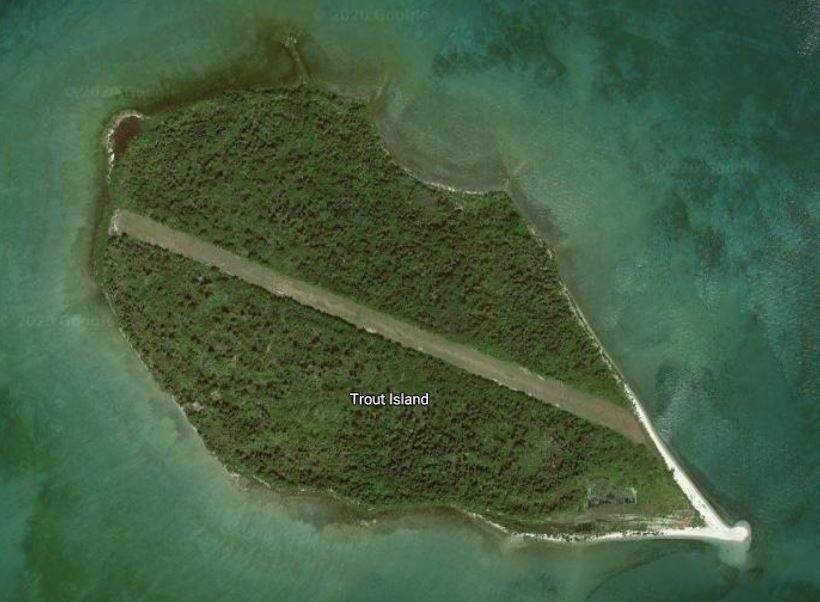 Source: Google Earth Thanks to Matt McKinley, Drummond Island (and Drummond Island Airport (KDRM)) has now been added to the list as well. It is a fairly big island bordering Canada on three sides. 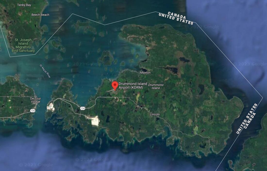 Source: Google Earth
For More Information The Michigan Department of Aeronautics offers an Airport Diagram app (for both Android and Apple products) with more information about these and other Michigan airports. You can learn more about it here: https://www.michigan.gov/aero/0,4533,7-352-79155_79156---,00.html So much exploring to do… Fly safe and fly often!
3 Comments
|
BLOGS ON THIS PAGEAuthorYasmina Platt ArchivesCategories |
 RSS Feed
